GeoPackage
- Author:
Jeff McKenna
- Contact:
jmckenna at gatewaygeomatics.com
- Last Updated:
2022-04-25
GeoPackage, also written as « GPKG », is a standards-based wrapper for the file-based SQLite database. GPKG is an encoding standard adopted by the Open Geospatial Consortium back in 2014, and has since gained popularity for distributing both vector & raster data, inside one compact file.

More Information
More information about GPKG is available at:
Official page: https://www.geopackage.org/
OGC’s GeoPackage Encoding Standard: https://www.ogc.org/standards/geopackage
File listing
Similar to other database formats, the .gpkg file consists of several tables. The geometry is held in a BLOB table column.
Note
Windows users who want to follow along, can convert MS4W’s included demo.db SpatiaLite database into a GPKG file (for the countries table) with the command (executed inside /ms4w/apps/local-demo/data/) :
ogr2ogr -f GPKG countries.gpkg demo.db countries
Data Access / Connection Method
GPKG access is available in MapServer through OGR’s GPKG driver. It is recommended to use GDAL/OGR version 2.2 or later for GPKG access.
OGR uses the names of spatial tables within the GPKG database (tables with a geometry column that are registered in the geometry_columns table) as layers.
The CONNECTION parameter must include the .gpkg extension, and the DATA parameter should be the name of the spatial table (or OGR layer).
CONNECTIONTYPE OGR
CONNECTION "name.gpkg"
DATA "layername"
Astuce
The MapServer 7.4.x series contained a few critical fixes for GPKG access, therefore at the minimum, at least MapServer 7.6.0 is recommended.
Step 1: Use ogrinfo to examine
First you should make sure that your local GDAL/OGR build contains both the « GPKG » driver & the « SQLite / Spatialite » driver, by using the –formats command:
ogrinfo --formats

   Supported Formats:
        ...
        GPKG -raster,vector- (rw+vs): GeoPackage
        SQLite -vector- (rw+v): SQLite / Spatialite
        ...
Once you have confirmed that you have the GPKG driver you are ready to try an ogrinfo command on your database to get a list of spatial tables:
ogrinfo countries.gpkg

  INFO: Open of `countries.gpkg'
        using driver `GPKG' successful.
  1: countries (Multi Polygon)
Now use ogrinfo to get information on the structure of the spatial “countries” table:
ogrinfo countries.gpkg countries -summary

      INFO: Open of `countries.gpkg'
            using driver `GPKG' successful.

      Layer name: countries
      Geometry: Multi Polygon
      Feature Count: 177
      Extent: (-180.000000, -90.000000) - (180.000000, 83.645130)
      Layer SRS WKT:
      GEOGCS["WGS 84",
          DATUM["WGS_1984",
              SPHEROID["WGS 84",6378137,298.257223563,
                  AUTHORITY["EPSG","7030"]],
              AUTHORITY["EPSG","6326"]],
          PRIMEM["Greenwich",0,
              AUTHORITY["EPSG","8901"]],
          UNIT["degree",0.0174532925199433,
              AUTHORITY["EPSG","9122"]],
          AUTHORITY["EPSG","4326"]]
      FID Column = ogc_fid
      Geometry Column = GEOMETRY
      featurecla: String (0.0)
      scalerank: Integer (0.0)
      labelrank: Integer (0.0)
      sovereignt: String (0.0)
      sov_a3: String (0.0)
      adm0_dif: Integer (0.0)
      ...
You can also use ogrinfo to verify that your GPKG table’s geometry has a spatial index, which is very important for performance (look for HasSpatialIndex (Integer) = 1 to confirm that the spatial index exists) :
ogrinfo -sql "SELECT HasSpatialIndex('countries', 'GEOMETRY')" countries.gpkg

  Layer name: SELECT
  Geometry: Unknown (any)
  Feature Count: 1
  Layer SRS WKT:
  (unknown)
  HasSpatialIndex: Integer (0.0)
  OGRFeature(SELECT):0
    HasSpatialIndex (Integer) = 1
If you need to create add a spatial index to your GPKG, you can also use ogrinfo :
ogrinfo -sql "SELECT CreateSpatialIndex('parcelle_graphique', 'geom')" PARCELLES_GRAPHIQUES.gpkg
If you are going to have MapServer filter or query a specific field in your GPKG, you should also consider adding an attribute index for that field:
ogrinfo -sql "CREATE INDEX IDXnewindexname ON yourtable (yourcolumn)" file.gpkg
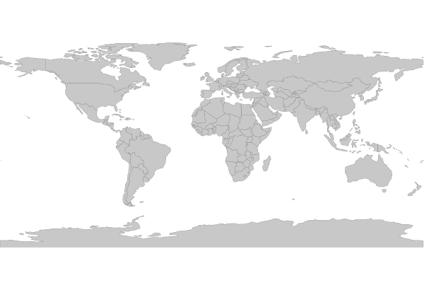
Step 2: Add the layer in your mapfile
For OGR connections, it is always recommended to set CONNECTIONTYPE, CONNECTION, and DATA, as follows:
/* Countries */
LAYER
  NAME "countries"
  TYPE POLYGON
  STATUS ON
  CONNECTIONTYPE OGR
  CONNECTION "countries.gpkg"
  DATA "countries"            # the OGR layername, found through ogrinfo
  EXTENT -180.000000 -90.000000 180.000000 83.645130 # for maximum performance
  PROCESSING "CLOSE_CONNECTION=DEFER" # for maximum performance
  CLASS
    NAME "World Countries"
    STYLE
      COLOR 200 200 200
      OUTLINECOLOR 0 0 0
      WIDTH 0.1
    END #style
  END #class
END #layer
Step 3: Test your Mapfile with map2img
Use the MapServer commandline utility map2img to verify that your mapfile creates a valid map image, and also display draw times, such as:
map2img -m geopackage.map -o ttt.png -map_debug 3

msDrawMap(): rendering using outputformat named png (AGG/PNG).
msDrawMap(): WMS/WFS set-up and query, 0.000s
msDrawMap(): Layer 0 (countries), 0.078s
msDrawMap(): Drawing Label Cache, 0.000s
msDrawMap() total time: 0.079s
msSaveImage(ttt.png) total time: 0.008s