


|
|
Home | Products | Issue Tracker | FAQ | Download |
|
|
Table of Contents
PostGIS spatially enables the Open Source PostgreSQL database.
The PostGIS wiki page may include additional information.
PostGIS is supported directly by MapServer and must be compiled into MapServer to work.
The PostgreSQL client libraries (libpq.so or libpq.dll) must be present in the system’s path environment for functionality to be present.
The CONNECTIONTYPE parameter must be set to POSTGIS.
The CONNECTION parameter is used to specify the parameters to connect to the database. CONNECTION parameters can be in any order. Most are optional. dbname is required. user is required. host defaults to localhost, port defaults to 5432 (the standard port for PostgreSQL).
The DATA parameter is used to specify the data used to draw the map. The form of DATA is “[geometry_column] from [table_name|sql_subquery] using unique [unique_key] using srid=[spatial_reference_id]”. The “using unique” and “using srid=” clauses are optional when drawing features, but using them improves performance. If you want to make MapServer query calls to a PostGIS layer, your DATA parameter must include “using unique”. Omitting it will cause the query to fail.
Here is a simple generic example:
CONNECTIONTYPE POSTGIS
CONNECTION "host=yourhostname dbname=yourdatabasename user=yourdbusername
            password=yourdbpassword port=yourpgport"
DATA "geometrycolumn from yourtablename"
This example shows specifying the unique key and srid in the DATA line:
CONNECTIONTYPE POSTGIS
CONNECTION "dbname=yourdatabasename user=yourdbusername"
DATA "the_geom from the_database using unique gid using srid=4326"
This example shows using a SQL subquery to perform a join inside the database and map the result in MapServer. Note the “as subquery” string in the statement – everything between “from” and “using” is sent to the database for evaluation:
CONNECTIONTYPE POSTGIS
CONNECTION "dbname=yourdatabasename user=yourdbusername"
DATA "the_geom from (select g.gid, g.the_geom, a.attr1, a.attr2 from
      geotable g join attrtable a on g.gid = a.aid) as subquery
      using unique gid using srid=4326"
This example shows using a geometry function and database sort to limit the number of features and vertices returned to MapServer:
CONNECTIONTYPE POSTGIS
CONNECTION "dbname=yourdatabasename user=yourdbusername"
DATA "the_geom from (select g.gid, ST_Simplify(g.the_geom, 10.0) as
      the_geom from geotable g order by ST_Area(g.the_geom) desc
      limit 10) as subquery using unique gid using srid=4326"
This example shows the use of the !BOX! substitution string to over-ride the default inclusion of the map bounding box in the SQL. By default the spatial box clause is appended to the SQL in the DATA clause, but you can use !BOX! to insert it anywhere you like in the statement. In general, you won’t need to use !BOX!, because the PostgreSQL planner will generate the optimal plan from the generated SQL, but in some cases (complex sub-queries) a better plan can be generated by placing the !BOX! closer to the middle of the query:
CONNECTIONTYPE POSTGIS
CONNECTION "dbname=yourdatabasename user=yourdbusername"
DATA "the_geom from (select g.gid, ST_Union(g.the_geom, 10.0) as
      the_geom from geotable g where ST_Intersects(g.geom,!BOX!)) as
      subquery using unique gid using srid=4326"
OGRINFO can be used to read out metadata about PostGIS tables directly from the database.
First you should make sure that your GDAL/OGR build contains the PostgreSQL driver, by using the ‘–formats’ command:
>ogrinfo --formats
  Loaded OGR Format Drivers:
  ...
  -> "PGeo" (readonly)
  -> "PostgreSQL" (read/write)
  -> "MySQL" (read/write)
  ...
If you don’t have the driver, you might want to try the FWTools or MS4W packages, which include the driver.
Once you have the driver you are ready to try an ogrinfo command on your database to get a list of spatial tables:
>ogrinfo PG:"host=127.0.0.1 user=postgres password=postgres dbname=canada port=5432"
      using driver `PostgreSQL' successful.
      1: province (Multi Polygon)
Now use ogrinfo to get information on the structure of the spatial table:
>ogrinfo PG:"host=127.0.0.1 user=postgres password=postgres dbname=canada port=5432"
             province -summary
 INFO: Open of `PG:host=127.0.0.1 user=postgres password=postgres dbname=canada'
    using driver `PostgreSQL' successful.

  Layer name: province
  Geometry: Multi Polygon
  Feature Count: 1068
  Extent: (-2340603.750000, -719746.062500) - (3009430.500000, 3836605.250000)
  Layer SRS WKT:
  (unknown)
  FID Column = gid
  Geometry Column = the_geom
  area: Real (0.0)
  island: String (30.0)
  island_e: String (30.0)
  island_f: String (30.0)
  name: String (30.0)
  ...
LAYER
  NAME "province"
  STATUS ON
  TYPE POLYGON
  CONNECTIONTYPE POSTGIS
  CONNECTION "host=127.0.0.1 port=5432 dbname=canada user=postgres password=postgres"
  DATA "the_geom from province"
  CLASS
     ...
  END
END
For more info about PostGIS and MapServer see the PostGIS docs: http://postgis.net/documentation/
PostGIS is able to store circular interpolated curves, as part of the SQL Multimedia Applications Spatial specification (read about the SQL/MM specification).
For more information about PostGIS’ support, see the SQL-MM Part 3 section in the PostGIS documentation, such as here.
As of MapServer 6.0, the PostGIS features CircularString, CompoundCurve, CurvePolygon, MultiCurve, and MultiSurface can be drawn through MapServer directly.
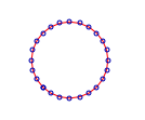
The following is the Well Known Text of the feature loading into PostGIS:
INSERT INTO test ( g, id ) VALUES ( ST_GeomFromText('CIRCULARSTRING(0 0,
                                    4 0, 4 4, 0 4, 0 0)', -1), 2);
An example MapServer layer might look like:
LAYER
  NAME "curves_poly"
  STATUS DEFAULT
  TYPE POLYGON
  CONNECTIONTYPE postgis
  CONNECTION "user=postgres password=postgres dbname=curves host=localhost port=5432"
  DATA "g from test using SRID=-1 using unique id"
  CLASS
    STYLE
      COLOR 128 128 128
      ANTIALIAS true
    END
  END
END
And testing with shp2img should produce a map image of:
The following is the Well Known Text of the feature loading into PostGIS:
INSERT INTO test ( g, id ) VALUES ( ST_GeomFromText('COMPOUNDCURVE(
                  CIRCULARSTRING(0 0, 1 1, 1 0),(1 0, 0 1))', -1), 3);
An example MapServer layer might look like:
LAYER
  NAME "curves_poly"
  STATUS DEFAULT
  TYPE POLYGON
  CONNECTIONTYPE postgis
  CONNECTION "user=postgres password=postgres dbname=curves host=localhost port=5432"
  DATA "g from test using SRID=-1 using unique id"
  CLASS
    STYLE
      COLOR 128 128 128
      ANTIALIAS true
    END
  END
END
And testing with shp2img should produce a map image of:

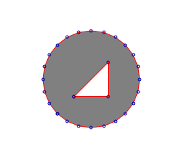
The following is the Well Known Text of the feature loading into PostGIS:
INSERT INTO test ( g, id ) VALUES ( ST_GeomFromText('CURVEPOLYGON(
                  CIRCULARSTRING(0 0, 4 0, 4 4, 0 4, 0 0),(1 1, 3 3,
                  3 1, 1 1))', -1), 4);
An example MapServer layer might look like:
LAYER
  NAME "curves_poly"
  STATUS DEFAULT
  TYPE POLYGON
  CONNECTIONTYPE postgis
  CONNECTION "user=postgres password=postgres dbname=curves host=localhost port=5432"
  DATA "g from test using SRID=-1 using unique id"
  CLASS
    STYLE
      COLOR 128 128 128
      ANTIALIAS true
    END
  END
END
And testing with shp2img should produce a map image of:
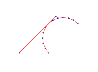
The following is the Well Known Text of the feature loading into PostGIS:
INSERT INTO test ( g, id ) VALUES ( ST_GeomFromText('MULTICURVE((0 0,
                  5 5),CIRCULARSTRING(4 0, 4 4, 8 4))', -1), 6);
An example MapServer layer might look like:
LAYER
  NAME "curves_poly"
  STATUS DEFAULT
  TYPE POLYGON
  CONNECTIONTYPE postgis
  CONNECTION "user=postgres password=postgres dbname=curves host=localhost port=5432"
  DATA "g from test using SRID=-1 using unique id"
  CLASS
    STYLE
      COLOR 128 128 128
      ANTIALIAS true
    END
  END
END
And testing with shp2img should produce a map image of:
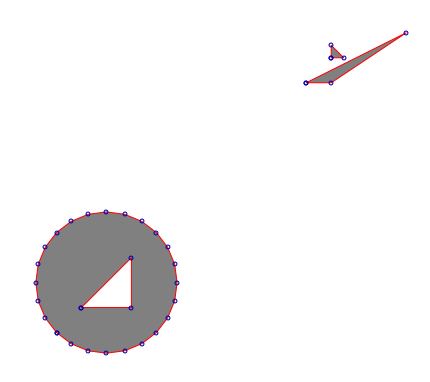
The following is the Well Known Text of the feature loading into PostGIS:
INSERT INTO test ( g, id ) VALUES ( ST_GeomFromText('MULTISURFACE(
                  CURVEPOLYGON(CIRCULARSTRING(0 0, 4 0, 4 4, 0 4,
                  0 0),(1 1, 3 3, 3 1, 1 1)),((10 10, 14 12, 11 10,
                  10 10),(11 11, 11.5 11, 11 11.5, 11 11)))', -1), 7);
An example MapServer layer might look like:
LAYER
  NAME "curves_poly"
  STATUS DEFAULT
  TYPE POLYGON
  CONNECTIONTYPE postgis
  CONNECTION "user=postgres password=postgres dbname=curves host=localhost port=5432"
  DATA "g from test using SRID=-1 using unique id"
  CLASS
    STYLE
      COLOR 128 128 128
      ANTIALIAS true
    END
  END
END
And testing with shp2img should produce a map image of:
If you cannot upgrade to MapServer 6.0, then you can use the PostGIS function ST_CurveToLine() in your MapServer LAYER to draw the curves (note that this is much slower however):
LAYER
  NAME "curves_poly"
  STATUS DEFAULT
  TYPE POLYGON
  CONNECTIONTYPE postgis
  CONNECTION "user=postgres password=postgres dbname=curves host=localhost port=5432"
  DATA "wkb_geometry from (select c.id, ST_CurveToLine(c.g) as
                           wkb_geometry from c) as subquery using
                           unique id using SRID=-1"
  CLASS
    STYLE
      COLOR 128 128 128
      ANTIALIAS true
    END
  END
END