


CLUSTER
Description
Since version 6.0, MapServer has the ability to combine multiple features from a point layer into single (aggregated) features based on their relative positions. Only POINT layers are supported. This feature was added through MS RFC 69: Support for clustering of features in point layers.
Supported Layer Types
Only layers of TYPE POINT are supported.
Mapfile Parameters
- MAXDISTANCE [double]
Specifies the distance of the search region (rectangle or ellipse) in pixel positions. Must be greater than 0.
- REGION [string]
Defines the search region around a feature in which the neighbouring features are negotiated. Can be 'rectangle' or 'ellipse'.
- BUFFER [double]
Defines a buffer region around the map extent in pixels. Default is 0. Using a buffer allows that the neighbouring shapes around the map are also considered during the cluster creation.
- GROUP [string]
This expression evaluates to a string and only the features that have the same group value are negotiated. This parameter can be omitted. The evaluated group value is available in the 'Cluster_Group' feature attribute.
- FILTER [string]
We can define the FILTER expression filter some of the features from the final output. This expression evaluates to a boolean value and if this value is false the corresponding shape is filtered out. This expression is evaluated after the the feature negotiation is completed, therefore the 'Cluster_FeatureCount' parameter can also be used, which provides the option to filter the shapes having too many or to few neighbors within the search region.
Supported Processing Options
The following processing options can be used with the cluster layers:
- CLUSTER_GET_ALL_SHAPES=ON
Return all shapes contained by a cluster instead of a single shape. This setting affects both the drawing and the query processing (especially useful for GetFeatureInfo requests). Example usage: PROCESSING "CLUSTER_GET_ALL_SHAPES=ON"
- CLUSTER_KEEP_LOCATIONS=ON
Set whether the location of the cluster shape should be preserved (setting this will show all points in the cluster). Example usage: PROCESSING "CLUSTER_KEEP_LOCATIONS=ON"
- CLUSTER_ALGORITHM=SIMPLE
From MapServer 6.2 we can choose a more simplified clustering algorithm which performs better that the original (more accurate) approach. usage: PROCESSING "CLUSTER_ALGORITHM=SIMPLE" For more information see:
Bug 5503
- CLUSTER_USE_MAP_UNITS=ON
Provide scale independent clustering (maxdistance and the buffer parameters are specified in map units). Example usage: PROCESSING "CLUSTER_USE_MAP_UNITS=ON"
- ITEMS
Specify the feature attributes in the cluster to expose during a query, separated by a comma. Example usage: PROCESSING "ITEMS=attribute_x,attribute_y,attribute_z"
Mapfile Snippet
LAYER
  NAME "my-cluster"
  TYPE POINT
  ...
  CLUSTER
     MAXDISTANCE 20  # in pixels
     REGION "ellipse"  # can be rectangle or ellipse
     GROUP (expression)  # an expression to create separate groups for each value
     FILTER (expression) # a logical expression to specify the grouping condition
  END
  LABELITEM "Cluster_FeatureCount"
  CLASS
    ...
    LABEL
     ...
    END
  END
  ...
END
Feature attributes
The clustered layer itself provides the following aggregated attributes:
Cluster_FeatureCount - count of the features in the clustered shape
Cluster_Group - The group value of the cluster (to which the group expression is evaluated)
Catatan
If you are using MapServer version 6.x these attributes contain a ":" in their names instead, such as Cluster:FeatureCount & Cluster:Group. The "_" was changed in MapServer 7.
These attributes (in addition to the attributes provided by the original data source) can be used to configure the labels of the features and can also be used in expressions. The ITEMS processing option can be used to specify a subset of the attributes from the original layer in the query operations according to the user's preference.
We can use simple aggregate functions (Min, Max, Sum, Count) to specify how the clustered attribute should be calculated from the original attributes. The aggregate function should be specified as a prefix separated by ':' in the attribute definition, like: [Max:itemname]. If we don't specify aggregate functions for the source layer attributes, then the actual value of the cluster attribute will be non-deterministic if the cluster contains multiple shapes with different values. The Count aggregate function in fact provides the same value as Cluster_FeatureCount.
Handling GetFeatureInfo
If you want to allow WMS GetFeatureInfo on all features inside a cluster, you must 1) set the "wms_include_items" metadata as usual, and 2) set the following PROCESSING parameters in the layer:
PROCESSING "CLUSTER_GET_ALL_SHAPES=ON"
PROCESSING "ITEMS=attribute_x,attribute_y,attribute_z"
So your layer might look like the following:
LAYER
  NAME "my-cluster"
  TYPE POINT
  METADATA
    "wms_title"    "myttitle"
    "wms_include_items" "all"
  END
  ...
  CLUSTER
     ...
  END
  LABELITEM "Cluster_FeatureCount"
  CLASS
    ...
    LABEL
     ...
    END
  END
  ...
  PROCESSING "CLUSTER_GET_ALL_SHAPES=ON"
  PROCESSING "ITEMS=name,description"
END
PHP MapScript Usage
The CLUSTER object is exposed through PHP MapScript. An example follows:
$map = ms_newMapobj("/var/www/vhosts/mysite/httpdocs/test.map");
$layer1=$map->getLayerByName("test1");
$layer1->cluster;
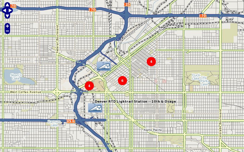
Example: Clustering Railway Stations
The following example uses a point datasource, in this case in KML format, to display clusters of railway stations. Two classes are used: one to style and label the cluster, and one to style and label the single railway station.
Catatan
Since we can't declare 2 labelitems, for the single railway class we use the TEXT parameter to label the station.
Mapfile Layer
####################
# Lightrail Stations
####################
SYMBOL
  NAME "lightrail"
  TYPE PIXMAP
  IMAGE "../etc/lightrail.png"
END
LAYER
    NAME "lightrail"
    GROUP "default"
    STATUS DEFAULT
    TYPE POINT
    CONNECTIONTYPE OGR
    CONNECTION "lightrail-stations.kml"
    DATA "lightrail-stations"
    LABELITEM "Cluster_FeatureCount"
    CLASSITEM "Cluster_FeatureCount"
    ###########################
    # Define the cluster object
    ###########################
    CLUSTER
      MAXDISTANCE 50
      REGION "ellipse"
    END
    ################################
    # Class1: For the cluster symbol
    ################################
    CLASS
      NAME "Clustered Lightrail Stations"
      EXPRESSION ("[Cluster_FeatureCount]" != "1")
      STYLE
        SIZE 30
        SYMBOL "citycircle"
        COLOR 255 0 0
      END
      LABEL
        FONT scb
        TYPE TRUETYPE
        SIZE 8
        COLOR 255 255 255
        ALIGN CENTER
        PRIORITY 10
        BUFFER 1
        PARTIALS TRUE
        POSITION cc
      END
    END
    ################################
    # Class2: For the single station
    ################################
    CLASS
      NAME "Lightrail Stations"
      EXPRESSION "1"
      STYLE
        SIZE 30
        SYMBOL "lightrail"
      END
      TEXT "[Name]"
      LABEL
        FONT scb
        TYPE TRUETYPE
        SIZE 8
        COLOR 0 0 0
        OUTLINECOLOR 255 255 255
        ALIGN CENTER
        PRIORITY 9
        BUFFER 1
        PARTIALS FALSE
        POSITION ur
      END
    END
    # the following is used for a query
    TOLERANCE 50
    UNITS PIXELS
    HEADER "../htdocs/templates/cluster_header.html"
    FOOTER "../htdocs/templates/cluster_footer.html"
    TEMPLATE "../htdocs/templates/cluster_query.html"
END
Map Image